
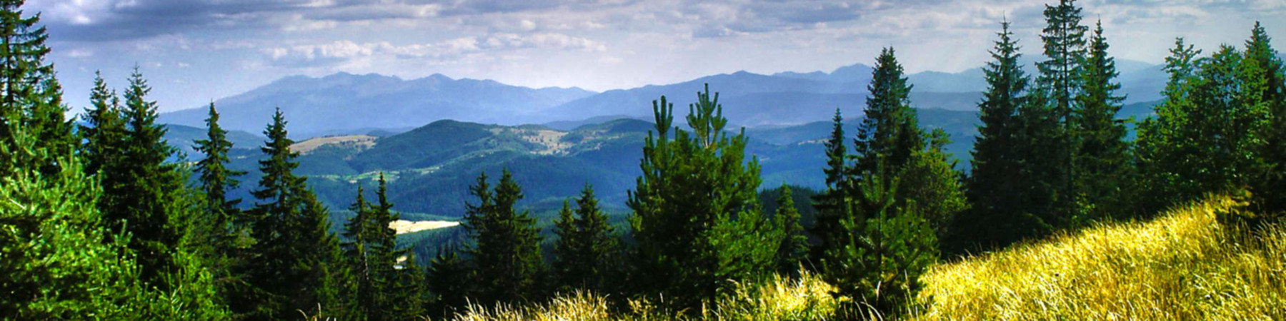
www.backpacker.com Did Hurricane Helene Really Destroy One-Third of the Appalachian Trail?
Our hiking columnist called experts along the Appalachian Trail to get a sense of the destruction left by Hurricane Helene


Late November in Michigan
It was supposed to rain, but we pressed on, and it ended up being beautiful. Chilly but pleasant. Just cold enough to make you appreciate the warm fire. Plus the sound of the river to lull you to sleep.
Hard to beat!
I usually go with dehydrated meals, but packed heavy on real food this time, for science. I got myself a small lightweight nonstick pan, and fried up a whole steak for dinner, bacon and eggs for first breakfast, and pancakes and eggs for the second breakfast. I only had one dehydrated meal this trip. I learned a lot!
Our hiking columnist called experts along the Appalachian Trail to get a sense of the destruction left by Hurricane Helene
While it is true that the Appalachian Trail Conservancy, the nonprofit that helps manage the path and the lands surrounding it, has advised hikers to stay off the southernmost 865 miles, or its lower third, it is not true that those miles are destroyed. Sources I spoke to talked of toppled trees, down branches, and flooding.
A Scandinavian Specialty
Scandinavia often has these three-walled cabins available on a first-come, first-served basis. In Swedish, they're called vindskydd, or wind shelter. This particular one is northeast of Umeå, Sweden. No guarantees on what they're called elsewhere, but I have seen them in Finland as well. And I have heard of but not seen of them in Norway. In general, the freedom to roam is quite strong in these three countries as long as you are respectful and stay out of obviously private spaces like personal gardens or farm fields. Happy travels!
Earnslaw Burn
Earnslaw Burn, under Mt Earnslaw (Glenorchy, New Zealand)
Bighorn Crags, Frank Church River of No Return Wilderness, ID (2023)
cross-posted from: https://iusearchlinux.fyi/post/417724
I day-hiked in to the Bighorn Crags area a couple of weeks ago. The Bighorn Crags are named for their bighorn sheep and really cool craggy granite mountains. They are quite old and eroded, with lots of cirques, crags, and towers. I would recommend getting to the trailhead and camping, then backpacking in for a few days.
Getting to the trailhead is a 2.5 hour drive from Salmon, Idaho through forest service roads. The first 1.5 hours are fine - well maintained dirt roads with easy grades. The last 18 miles takes an hour on a really crappy road deep into the mountains. Tire popper rocks abound, so be careful and be prepared! There is a campground at the trailhead.
The trail system is such that you hike along a ridge line for about six miles until you reach the major crags.
Bear Basin to Thompson Lake, Lee Metcalf Wilderness, MT USA (2022)
cross-posted from: https://iusearchlinux.fyi/post/277201
I took this out-and-back hike in August 2022. It was a 9.3 mile hike one way. You start in relatively populated national forest land and then as you rise through the mountains, reach the Wilderness area. The trail climbs through Bear Basin, switch backing up the bowl of the basin to the first pass, which is stunning. The descent down the pass is rough with lots of steep gravel. The trail splits and you take the high trail to the east, over the next pass to Summit Lake, which is nestled between two mountains, then over the lass tiny pass and down into the last, big basin. Hike along the meadow until you reach Thompson Lake at the foot of Gallatin peak. You can summit the peak, but I didn't. I surely didn't see a reasonable trail up it!
.
So pros:

Steve Curry, an experienced and inveterate hiker from Sunland, is believed to be the second person to die in Death Valley's searing heat this year.

A 71-year-old Los Angeles man died in California’s Death Valley National Park on Tuesday, likely due to heat, as the afternoon high recorded in the park was 121 degrees, officials said. The Inyo County Coroner identified the deceased as Steven Curry.
Curry fell to the ground outside the restroom at the Golden Canyon trailhead, the Inyo County Sheriff’s Office and the national park wrote in a news release.
Before collapsing, Curry had been interviewed in the early morning by a Los Angeles Times reporter at Zabriskie Point; he had hiked about 2 miles from Golden Canyon to the point.
Palisades hike to Waterfall Canyon, Idaho 2023
cross-posted from: https://iusearchlinux.fyi/post/66105
As promised, here is a trip report!
Trailhead: Palisades campground Path: hike past Lower Palisades lake (4 mi), Upper Palisades lake (7 mi) and into Waterfall Canyon (end at 11 miles).
The snow has melted and the Palisades are in full growth mode! Tons of flowers are blooming or preparing to bloom in the next couple of weeks. Patches of snow still exist in Waterfall Canyon starting at about 7400 ft elevation. There were two waterfalls flowing at the end of the canyon. We camped in some nice established campsites to the west of the trail by one of the lakes at the end of the canyon. It was a quiet day with no other people out past Upper Lake.
(Palisades creek is super fast this year!) (Upper Palisades Lake is beau
Goldbug Hot Springs, near Salmon, ID (2023)
cross-posted from: https://iusearchlinux.fyi/post/354323
Did a quick day hike last weekend to Goldbug Hot Springs in Elk Bend, ID. It's a little under 2 miles one way, and about 900' elevation gain - half of it in the last quarter-mile. You start at a trailhead next to private land and hike about a quarter-mile through private land (it's allowed but stay on trail, dogs on leash and keep your noise level down).
It was very hot in the afternoon and there is little cover, it improves as you approach the hot springs. The springs actually spring cold water and hot water, and some pools are hotter than others, so explore!
The map
The approach - the springs are up in the mountains
The vew from the springs back down  back in 2020.
Sadly, most thru-hikers on the Pacific Crest Trail or the John Muir Trail will hustle past here, as they’re always trying to get from Muir Pass to Muir Trail Ranch (or vice versa, if they’re southbound) in a day. But, it’s a beautiful place, worth stopping to see at different times of day.
Deer grazed in the meadow, as well as in my campsite as I made my morning coffee. If you’re an angler, Evolution Creek is full of golden trout, and make for a fantastic diet addition along the trail.
It is one of the most peaceful places in the Sierra Nevada, if you visit at the right time of year. This was back in late 2020, and I was able to be all alone here, due to the pandemic keeping the backpackers’ numbers down.
Cheap, good quality camping items found on Aliexpress
A link to a website if you want to buy good quality hiking items on aliexpress.
The ratio price/weigth is usually good, not ultralight, but correct
Backpacking on the Te Araroa trail in New Zealand
This was taken last January during my wife and I's thru hike of Te Araroa. Photo credit~ my wife.
Kings Mountain Summit (OR, USA)
Recently did a 2 day trip that looped up to this summit. There were some intense inclines and a few scrambles, but the views were incredible.